Ten Mooresville areas compared: ZIP code, zoned high school and typical home value. Two school districts split the town, and zones do not follow town limits.
Last checked Oct. 11, 2026. Sources: the Town of Mooresville’s Mooresville Tomorrow 2040 plan, the National Register nominations, OpenStreetMap place names, the two school districts’ zone finders (Mooresville Graded, Iredell-Statesville), the N.C. Department of Public Instruction’s 2025-26 accountability data, the U.S. Census Bureau’s geocoder and QuickFacts and Zillow Research.
Mooresville is a town of 52,381 people, by the Census Bureau’s 2020-2024 American Community Survey estimates, on the east shore of Lake Norman in southern Iredell County. I-77 runs north and south through it, with exits at Langtree Road (31), U.S. 21 (33), Brawley School Road (35) and N.C. 150 (36). Three facts shape where you live here more than any neighborhood name:
- Two ZIP codes, two markets. 28117 is mostly the lake side west of I-77; 28115 covers downtown and the town to the east. Zillow’s typical value was $631,168 in 28117 and $402,878 in 28115 in August 2026.
- Two school districts. The Mooresville Graded School District serves downtown and most of the town east of I-77. Iredell-Statesville Schools, the county district, serves the lake side, the south end and the north. School zones do not follow the town limits: Mazeppa Park is inside the town but zoned for Iredell-Statesville schools.
- Town or county. A Mooresville mailing address can be in unincorporated Iredell County, which changes your tax bill and who picks up your trash. Most of the Brawley School Road peninsula and Shepherds are outside the town.
What this means for you
- Look up any address in both school finders: Mooresville Graded and Iredell-Statesville.
- Check whether a parcel is in the town with Iredell County’s Online Tax Services or the town’s sanitation map.
- Zillow’s figures are a modeled typical value for the middle third of homes in a ZIP code, not a sale price.
The areas at a glance
High school is the one zoned at the points we checked; home value is the Zillow Home Value Index for the area’s ZIP code in August 2026.
| Area | ZIP code | Zoned high school | Typical home value | Guide |
|---|---|---|---|---|
| Downtown | 28115 | Mooresville High | $402,878 | Downtown |
| Mill Village | 28115 | Mooresville High | $402,878 | Mill Village |
| South Mooresville | 28115 | Mooresville High; Lake Norman High at the south edge | $402,878 | South Mooresville |
| Mazeppa | 28115; 28125 to the east | South Iredell High; Mooresville High nearest town | $402,878 (28115) | Mazeppa |
| Shepherds | 28115, 28117 | South Iredell High | $402,878 / $631,168 | Shepherds |
| Doolie and N.C. 150 west | 28117 | Lake Norman High | $631,168 | Doolie |
| Williamson Road | 28117 | Lake Norman High | $631,168 | Williamson Road |
| Brawley School Road | 28117 | Lake Norman High | $631,168 | Brawley School Road |
| Langtree | 28117, 28115 | Lake Norman High | $631,168 / $402,878 | Langtree |
| Mount Mourne | 28117, 28115 | Lake Norman High | $631,168 / $402,878 | Mount Mourne |
In 2025-26, 60.3% of state tests at Mooresville High were at grade level or above, 68.1% at Lake Norman High and 64.8% at South Iredell High, the state’s accountability data shows. All three graduated more than 94% of students in four years. Zillow’s typical value for the whole town was $478,099. More in our schools guide and home prices guide.
Map
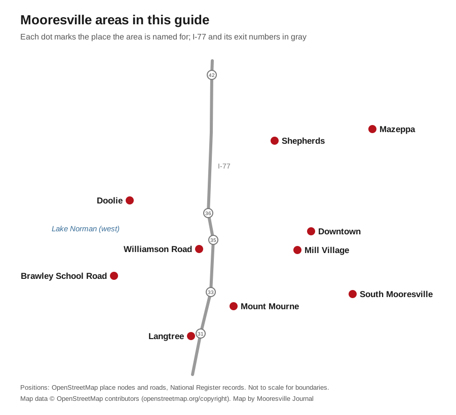
Map data © OpenStreetMap contributors. The dots mark the place each area is named for, not its boundaries.
East of I-77: the Mooresville Graded side
Downtown. The old railroad town on Main and Broad streets, a National Register historic district, with Liberty Park and older houses on the grid around it. Zoned for Mooresville Graded schools, split between Park View and South elementary.
Mill Village. About 160 acres of early 1900s mill houses south of downtown, built by Mooresville Cotton Mill and listed on the National Register in 2012. Mooresville Graded schools; Nesbit Park is inside it.
South Mooresville. Coddle Creek Highway, Shearers Road and Rocky River Road, with Mooresville Middle, Mooresville Intermediate, Rocky River Elementary and 46-acre Bellingham Park. The town’s plan targets “southern Mooresville” for a new east-west road and activity centers.
Mazeppa. Northeast Mooresville along Mazeppa Road, home to 163-acre Mazeppa Park. The school district line runs through it: most points we checked were Iredell-Statesville and South Iredell High.
North: Shepherds
Shepherds. Charlotte Highway (U.S. 21) toward Troutman, mostly unincorporated, zoned for Shepherd Elementary and South Iredell High. The plan proposes a new I-77 interchange at Exit 38 on Cornelius Road and a “Northern Gateway” district around it.
West of I-77: the lake side
Doolie and N.C. 150 west. Shopping centers on River Highway and subdivisions toward the lake, around Lake Norman High on Doolie Road. NCDOT is widening N.C. 150 and rebuilding Exit 36.
Williamson Road. The supermarket and strip-center corridor just west of Exit 35, with neighborhoods behind it; zoned for Lake Norman Elementary and Lake Norman High.
Brawley School Road. A long peninsula between arms of Lake Norman, mostly unincorporated, zoned for the Woodland Heights schools and Lake Norman High.
South end: I-77 Exits 31 and 33
Langtree. Exit 31 at Langtree Road, the closest Mooresville area to Charlotte, about 29 miles by road from the airport. The plan’s east-west connector starts here.
Mount Mourne. Between Exits 31 and 33 east of the interstate, a mix of an office campus, older homes and new subdivisions; zoned for Coddle Creek Elementary and Lake Norman High even on the town side.
How we built this
- Which areas. We used only places a source names and puts on a map. The town’s Mooresville Tomorrow 2040 plan, adopted Sept. 21, 2026, names the historic downtown, the Brawley School Road, Williamson Road and N.C. 150 corridors, the Exit 38 “Northern Gateway” and “southern Mooresville.” The National Register lists the Mooresville Historic District and the Mill Village. OpenStreetMap place nodes name Langtree, Mount Mourne, Shepherds, Mazeppa, Doolie and Mayhew. “South Mooresville” is our label for the area the plan calls southern Mooresville.
- Left out. We found no neighborhood or homeowners association registry on the town’s site, so we name no subdivisions. The plan also names the Statesville Highway and N.C. 115 corridors but gives them no boundaries, so they have no pages of their own; the Exit 38 area is covered on the Shepherds page. OpenStreetMap places farther from town, such as Shinnville and Bells Crossroads, are not included.
- Schools. We checked 55 points across the 10 areas in both districts’ zone finders and report what came back, and checked each point’s town, ZIP code and school district with the Census Bureau’s geocoder. Zones change; check your own address.
- Distances are measured on OpenStreetMap roads with the OSRM routing engine. They are distances, not drive times.
Comparing towns instead? See Mooresville vs Davidson vs Cornelius vs Kannapolis, and our moving to Mooresville guide.
Frequently asked questions
What are the neighborhoods in Mooresville, N.C.?
This guide covers 10 areas named in the town’s plan, the National Register or OpenStreetMap: Downtown, the Mill Village, South Mooresville, Mazeppa, Shepherds, Doolie, Williamson Road, Brawley School Road, Langtree and Mount Mourne.
Which school district is my Mooresville address in?
It depends on the address, not the town. The Mooresville Graded School District covers downtown and most of the town east of I-77; Iredell-Statesville Schools covers the lake side west of I-77, the south end around Langtree and the north around Shepherds. Check both districts’ finders.
What is the difference between ZIP codes 28115 and 28117?
28117 is mostly the Lake Norman side west of I-77, and its Zillow typical home value was $631,168 in August 2026. 28115 covers downtown and most of the town to the east, at $402,878.
Is every Mooresville address inside the town?
No. Much of the Brawley School Road peninsula, Shepherds and parts of other areas are in unincorporated Iredell County with Mooresville mailing addresses. That changes your property tax rate and trash service.
What is the population of Mooresville?
52,381, according to the Census Bureau’s 2020-2024 American Community Survey five-year estimates.
Have your say